#36 Weekly Remote Sensing and Geoscience news!
Landsat DEM source data now available for download; Aeolus enhances volcanic ash for aviation safety; EOSDA Gets First Ready-to-Use Images From Its EOS SAT-1 Satellite and more!
These are the topics of our #36 newsletter issue:
🛰 Landsat DEM source data now available for download
🛰 Aeolus enhances volcanic ash for aviation safety
🛰 EOSDA Gets First Ready-to-Use Images From Its EOS SAT-1 Satellite
🛰 Upcoming events
🛰 Week's recommended reading
If you are not a subscriber, please, consider it. You are very welcome.
Landsat DEM source data now available for download
These DEM sources have been modified for use in Collection 2 Level-1 data processing. Void-filling techniques were used where persistent gaps were found in the elevation data, and improvements to the vertical accuracy were realized by differencing accuracies of other elevation datasets to the newer Collection 2 DEM.
🛰️ Global Land Survey (GLS)
🛰️ Radarsat Antarctic Mapping Project (RAMP)
🛰️ Gravity for Earth, Ocean and Ice Dynamics (GEOID) Model
📰 Read more: Landsat Collection 2 Digital Elevation Model
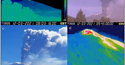
Aeolus enhances volcanic ash for aviation safety
🌋 Forecasting volcanic ash in the atmosphere is crucial for aviation, as ash can interfere with aircraft navigational instruments and can even damage engine parts.
🌋 In the new paper, it was found that the predictions of the volcanic ash plume position shifted considerably when Aeolus data were incorporated. According to the PANGEA observations, forecasts that drew on Aeolus data displayed a considerable improvement in the simulated shape and position of the ash cloud.
📰 Read more: Aeolus enhances volcanic ash for aviation safety
📰 Read the new paper: Aeolus winds impact on volcanic ash early warning systems for aviation
EOSDA Gets First Ready-to-Use Images From Its EOS SAT-1 Satellite
🛰️ EOS SAT is a constellation comprising seven small optical satellites designed to support the implementation of sustainable agriculture methods and forestland monitoring with high-quality data and analysis.
🛰️ After reaching full operation by 2025, the constellation will cover up to 100% of countries with the largest areas of farmlands and forestlands, amounting to 98.5% of such lands across the globe.
📰 Read more: EOSDA Gets First Ready-to-Use Images From Its EOS SAT-1 Satellite
UPCOMING EVENTS
Sinergise Summer School – Earth Observation: From satellite imagery to modern applications
Training School: Habitat Mapping and Trophic Ecology of Marine Animal Forests
NASA ARSET: Monitoring Water Quality of Inland Lakes Using Remote Sensing
Maximize your potential! Explore the most complete list of training, events, conferences, and workshops at Geoportal.tech. (👥 Jéssica Uchôa)
Week's recommended reading
Some highlights of this paper:
🌱 50 % of seagrass meadows have disappeared in the last 2 decades.
🌱 Mapping and assessing seagrass blue carbon storage and sequestration
🌱 InVEST Blue Carbon model for past, current, and future scenarios
🌱 C stock in the Canary Islands corresponds to 1.5 % nationally and 0.015 % globally.
🌱 A proposal through blue carbon assessment to support decision-making.
📰 Read more: Mapping and assessing seagrass meadows changes and blue carbon under past, current, and future scenarios
📰 You can check all my recommended papers at the bottom below:
Thanks for reading! See you next week!
Don't forget to like it and comment.
I appreciate it and I love to hear from you.
With love,
— Rafaela Tiengo


