Remote Sensing News

Share this post

#28 Weekly Remote Sensing and Geoscience news! πŸ›°οΈπŸŒ

rafaelatiengo.substack.com

Discover more from Remote Sensing News

A newsletter with the most recent news, tips, tutorials, conferences and more about Remote Sensing and Geoscience. Feel free to subscribe!
Over 2,000 subscribers
Continue reading
Sign in

#28 Weekly Remote Sensing and Geoscience news! πŸ›°οΈπŸŒ

Volcanic activity has been observed on Venus for the first time; Landsat 9 Collection 2 Level-3 products are now available; Scientists sound the alarm over a growing trash problem in space, and more!

Rafaela Tiengo πŸ›°οΈ
Mar 18, 2023
3
Share this post

#28 Weekly Remote Sensing and Geoscience news! πŸ›°οΈπŸŒ

rafaelatiengo.substack.com
Share

These are the topics of our #28 newsletter issue:

πŸ›° Recent volcanic activity has been observed on Venus for the first time.
πŸ›° Landsat 9 Collection 2 Level-3 products are now available
πŸ›° Sentinel Hub webinar: Arctic Wildfires - What can (and can’t) we know from satellites?
πŸ›° Brazil's president is negotiating to build a new satellite to monitor deforestation in the Amazon
πŸ›° Announcement of opportunity for SAOCOM
πŸ›° Scientists sound the alarm over a growing trash problem in space

If you are not a subscriber, please, consider it. You are very welcome.


This is a free newsletter in order to make science more accessible to all of you.
Would you like to support me? You can easily buy me a coffee (or a book) at the bottom below. :)

I would like to support you

If you can't do it, don't worry. You are always very welcome. πŸ’š

I wish you a good read! :)


Recent volcanic activity has been observed on Venus for the first time

πŸŒ‹ Scientists made the discovery after poring over archival radar images of Venus taken more than 30 years ago, in the 1990s, by NASA’s Magellan mission.

πŸŒ‹ The images revealed a volcanic vent changing shape and increasing significantly in size in less than a year
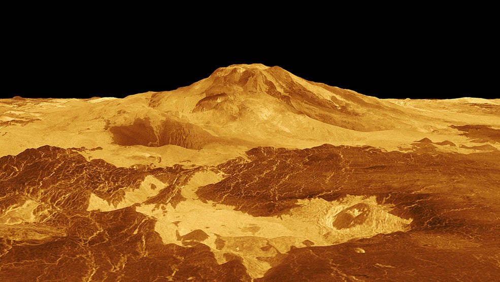
This computer-generated 3D model of Venus’ surface shows the summit of Maat Mons, the volcano that is exhibiting signs of activity. A new study found one of Maat Mons’ vents became enlarged and changed shape over an eight-month period in 1991, indicating an eruptive event occurred. Credits: NASA/JPL-Caltech

πŸ“° The search and its conclusions are described in a new study published in the journal Science: Surface changes observed on a Venusian volcano during the Magellan mission

Twitter avatar for @NASA
NASA @NASA
Recent volcanic activity has been observed on Venus for the first time. Scientists made the discovery by poring over archival radar images of Earth’s twin taken in the '90s by our Magellan mission. Our VERITAS mission is set to investigate: go.nasa.gov/3mP5f9O
A computer-generated 3D image shows the entirety of Venus in a bright yellow color. There are patches of darker yellows that illustrate differences in the surface. The large circular planet has a black square to the middle-right section marking where volcanic activity was spotted in archival radar images from NASA's Magellan mission.
10:16 PM βˆ™ Mar 16, 2023
15,703Likes1,926Retweets

Landsat 9 Collection 2 Level-3 products are now available

πŸ›°οΈ The Landsat 9 Dynamic Surface Water Extent (DSWE) and Fractional Snow Cover Area (fSCA) science products are now available to download from EarthExplorer and the Commercial Cloud.

Twitter avatar for @USGSLandsat
USGS Landsat @USGSLandsat
#LandsatHeadline: The Landsat 9 DSWE and fSCA science products are now available to download! πŸ₯³ Other L9 Level-3 science products will be released when reprocessing efforts are complete. Additional information will be posted then. Full Headline: ow.ly/bBBj50NhrRz
The Landsat 9 DSWE and fSCA science products are now available to download!  The production of Landsat 9 Burned Area science products and the annual fSCA Statistics will be delayed until all Landsat 9 reprocessing has completed. Additional information will be posted when the reprocessing effort is complete.
3:03 PM βˆ™ Mar 14, 2023
49Likes12Retweets

Sentinel Hub webinar: Arctic Wildfires - What can (and can’t) we know from satellites?

πŸ”₯ Satellite data are extremely useful in monitoring wildfire activity, including in the Arctic.

πŸ”₯ You will explore, whether and how this can actually be seen through the EO data.

πŸ”₯ You will also learn about the role of climate change in the occurrence of these fires and how this process might further drive climate change.

Twitter avatar for @Pierre_Markuse
Pierre Markuse @Pierre_Markuse
🟠 Interested in #arctic #wildfiresπŸ”₯ and #RemoteSensing? In this @sentinel_hub webinar @DrTELS (Dr Thomas Smith) will talk about "What can (and can’t) we know from satellites?", #ClimateChange, and zombie fires. 🟑 Info and Register for free here ▢️ events.teams.microsoft.com/event/94ee2592…
Sentinel Hub Webinar Logo announcing the "Arctic Wildfires - What can (and can’t) we know from satellites?" webinar on April 6th 2023 at 4pm CEST
3:43 PM βˆ™ Mar 15, 2023
73Likes42Retweets

Brazil's president is negotiating to build a new satellite to monitor deforestation in the Amazon

πŸ›°οΈ The agreement provides that the satellite will be binational and without military use.

πŸ›°οΈ The main news is that the new generation of satellites will have radars, something that did not exist in previous projects.

πŸ“° Read more (in Portuguese): Lula negocia com China novo satΓ©lite

Twitter avatar for @RafaelaTiengo_
Rafaela Tiengo πŸ‡§πŸ‡·πŸ›°οΈ @RafaelaTiengo_
Brazil's president @LulaOficial is negotiating with China to build a new satellite that could be used to monitor deforestation in the #Amazon and climate observationπŸ‡§πŸ‡·πŸ›°οΈ The main news is: the new generation of satellites will have radars #CBERS #EOchat #GISchat #EarthObservation
Twitter avatar for @UOLNoticias
UOL NotΓ­cias @UOLNoticias
πŸš€ O presidente Lula estΓ‘ negociando com a China a construΓ§Γ£o de um novo satΓ©lite que poderΓ‘ ser utilizado para monitorar o desmatamento na AmazΓ΄nia e observaΓ§Γ£o climΓ‘tica https://t.co/HDFijtjBMY
6:40 PM βˆ™ Mar 16, 2023
22Likes4Retweets

Announcement of opportunity for SAOCOM

πŸ‘©πŸΎβ€πŸ’» ESA is launching an opportunity for the international scientific community to access data from SAOCOM Mission for science and EO-base applications development.

πŸ“° Read more: ESA's announcement of opportunity for SAOCOM

Twitter avatar for @Montse_delr
Montse Del Riego @Montse_delr
πŸ’‘ Great opportunity to access #SAOCOM data through ESA's Third Party Missions (TPM) Programme! In cooperation with @CONAE_Oficial, @esa is launching an AO to access data from the SAOCOM mission for science and EO-based applications development rb.gy/mb07bm
Title: SAOCOM
Description: Artist’s impression of SAOCOM
Copyright: CONAE
9:39 AM βˆ™ Mar 14, 2023
6Likes3Retweets

Scientists sound the alarm over a growing trash problem in space

πŸ›°οΈ Currently, 9,000 active satellites are in orbitβ€”a number expected to grow to over 60,000 by 2030 and 100 trillion objects are currently circling the planet.

πŸ›°οΈ The 100 trillion figure includes everything from spent boosters and stray bolts to metal flecks and floating paint chips that went along with launching all of that hardware.

πŸ“° Read more: Scientists Sound the Alarm Over a Growing Trash Problem in Space

Twitter avatar for @RafaelaTiengo_
Rafaela Tiengo πŸ‡§πŸ‡·πŸ›°οΈ @RafaelaTiengo_
"Sixty-six years ago, there was just a single human-built object in Earth orbit: Sputnik. Currently, 9,000 active satellites are in orbitβ€”a number expected to grow to over 60,000 by 2030 and 100 trillion objects are circling the planet." πŸ€―πŸ›°οΈπŸŒ #EOchat time.com/6262389/space-…
time.comScientists Sound the Alarm Over a Growing Trash Problem in SpaceEven tiny pieces of junk can pose serious risks to astronauts
2:27 PM βˆ™ Mar 18, 2023
11Likes2Retweets

Week's recommended reading

In this paper, the authors recognized three major research themes regarding the characteristics of land use and land cover (LULC) data, different simulated scenarios of LULC changes, and the role of future scenarios for both LULC and landslide susceptibility.

πŸ“° Land use and land cover as a conditioning factor in landslide susceptibility: a literature review

πŸ“° You can check all my recommended papers at the bottom below:

Recommended Readings


Thanks for reading! See you next week!

Don't forget to like it and comment.

I appreciate it and I love to hear from you.

With love,

β€” Rafaela Tiengo

3
Share this post

#28 Weekly Remote Sensing and Geoscience news! πŸ›°οΈπŸŒ

rafaelatiengo.substack.com
Share
Comments
Top
New
Community

No posts

Ready for more?

Β© 2023 Rafaela Tiengo πŸ‡§πŸ‡·πŸ›°οΈ
Privacy βˆ™ Terms βˆ™ Collection notice
Start WritingGet the app
Substack is the home for great writing