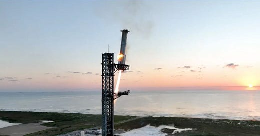
EO NEWS 63: SpaceX's Starship takes off and lands in an ambitious test
ICEYE announces new Dwell Precise imaging mode with 25 cm resolution.
📰 Latest news // Últimas notícias
🗺️ New Landsat-5 TM data collections, covering periods from 1985 to 1999 in Europe and North Africa, are now available to users. Novas coleções de dados do Landsat-5 TM, abrangendo períodos de 1985 a 1999 na Europa e no Norte da África, agora estão disponíveis para os usuários.
🛰️ ICEYE announces new Dwell Precise imaging mode providing 25 cm resolution. ICEYE anuncia novo modo de imagem Dwell Precise com resolução de 25 cm.
🌳 Planet Renews Contract with the Federal Police of Brazil for its global daily monitoring of threatened rainforests. Planet renova contrato com a Polícia Federal do Brasil para monitoramento diário global de florestas tropicais ameaçadas.
🚀 The Copernicus Sentinel-1C satellite has arrived in French Guiana and is preparing to be launched on a Vega-C rocket at the end of 2024. O satélite Copernicus Sentinel-1C chegou à Guiana Francesa e está se preparando para ser lançado em um foguete Vega-C no final de 2024.
🌪️ Maps and charts: Visualizing Milton’s historic impact across Florida. Mapas e gráficos: Visualizando o impacto histórico de Milton na Flórida.
🚀 SpaceX's Starship takes off and lands in an ambitious test. A Starship da SpaceX decola e pousa em um teste ambicioso.
📚 Interesting materials // Materiais interessantes
🌪️ Get the latest USGS resources on post-Helene landslides, including a map of current landslide observations and an event overview. Obtenha os recursos mais recentes do USGS sobre deslizamentos de terra pós-Helene, incluindo um mapa de observações atuais de deslizamentos de terra e uma visão geral do evento.
📚 Blog post (in Portuguese) - "Projeto Centinela: Monitoramento de Áreas Críticas Vulneráveis de Biodiversidade para Ações de Conservação". Saiba mais sobre o projeto que visa gerar dados globais para a conservação da biodiversidade, ajudando a prevenir a extinção das espécies mais ameaçadas.
📚 Here is a list of books for learning geospatial analysis and remote sensing with Python. Aqui está uma lista de livros para aprender análise geoespacial e sensoriamento remoto com Python.
This is a free newsletter in order to make science more accessible to all of you.
Did you find this newsletter helpful? Consider subscribing or upgrading to the paid version for less than €5 per month to support my work.
If you’re unable to, no worries — you're always warmly welcome here. 💚
💪🏾 Window of opportunity // Janela de oportunidade
The International Competition “Ecoview” - an ecological project competition open to school students of all ages, covering Ecology, Geography, and related disciplines. Competição Internacional “Ecoview” - uma competição de projetos ecológicos aberta a estudantes de todas as idades, abrangendo Ecologia, Geografia e disciplinas relacionadas.
A New Call from the Clean Energy for EU islands secretariat. Nova chamada do secretariado de energia limpa para ilhas da UE.
Innovative Copernicus training program designed specifically for African professionals. Programa de treinamento inovador do Copernicus projetado especificamente para profissionais africanos.
💼 Job offers // Oportunidades de emprego
Internal Research Fellow (PostDoc) in EO for Polar Science (Frascati, Italy)
Geological Scientist - Spectral Geologist (Anchorage, Alaska)
Analista de Geoprocessamento - Meteorologia (São Paulo, Brasil)
Estágio em Geografia (Brasília, Brasil)
Analista de Geoprocessamento (Minas Gerais, Brasil)
Geospatial Database Manager (Florida, USA)
GIS Support Specialist (Bendigo, Australia)
GIS Analyst (Florida, USA)
Assistant Professor in Climate, Environment and Urban Policy - Energy and Climate (Cambridge, UK)
Senior Advisor, Geographical Information Systems (Nairobi, Kenya)
Senior to Associate Spatial Scientist (Queensland, Australia)
Internships at the Canadian Space Agency (Longueuil or Remote)
Estagiário Técnico em Geoprocessamento (Vitória, Brasil)
GIS Analyst - Planning (Texas, USA)
Scientist I - Remote Sensing for Climate Finance (Rome, Italy)
Estágio em Geoprocessamento (Juiz de Fora, Brasil)
GIS Analyst (Arizona, USA)
Head of Geographic Information & Remote Sensing (Swindon, UK)
National Researcher - Geospatial Hydrology (Accra, Ghana)
Programme Associate - GIS (Colombo, Sri Lanka)
GIS Intern (Berlin, Germany)
📆 Upcoming events // Próximos eventos
Future Focus - Wildfires (Darmstadt, Germany)
Encontro de Utilizadores Esri Portugal (Lisboa, Portugal)
First Workshop on Computer Vision for Geospatial Image Analysis (Arizona, USA)
International Workshop on Space Resources: Perspectives for Future Ecosystems 2024 (São Paulo, Brasil)
🤳 My content // Meu conteúdo
📢 Copernicus Emergency Management Service activated for the fires in Portugal. 🔥 🛰️ 🇵🇹 Serviço de Gestão de Emergências Copernicus ativado para os incêndios em Portugal.
Here is an overview of the Terra em Foco 2024 conference, which took place on September 12th and 13th (📍Braga, Portugal). Aqui fica um resumo da conferência Terra em Foco 2024, que decorreu nos dias 12 e 13 de setembro (📍Braga, Portugal).
My last paper! It's a systematic literature review based on remote sensing approaches for land use/land cover change in coastal areas and oceanic islands. Meu último artigo! É uma revisão sistemática de literatura baseada em abordagens de sensoriamento remoto para mudança de uso/cobertura da terra em áreas costeiras e ilhas oceânicas.
This is a free newsletter in order to make science more accessible to all of you.
Did you find this newsletter helpful? Consider subscribing or upgrading to the paid version for less than €5 per month to support my work.
If you’re unable to, no worries — you're always warmly welcome here. 💚


