


#37 Weekly Remote Sensing and Geoscience news!
Azores archipelago (Portugal) with a new space radar to track satellites and debris; Unprecedented Water Recovery: US-German Satellites Reveal California's Remarkable Post-Winter Progress; more.

These are the topics of our #37 newsletter issue:
🛰 Azores archipelago (Portugal) with a new space radar to track satellites and debris
🛰 Unprecedented Water Recovery: US-German Satellites Reveal California's Remarkable Post-Winter Progress
🛰 Early Indications of El Niño Detected by Global Sea Level Satellite
🛰 How Do We Know Mauna Loa Carbon Dioxide Measurements Don't Include Volcanic Gases?
🛰 Upcoming events
If you are not a subscriber, please, consider it. You are very welcome.
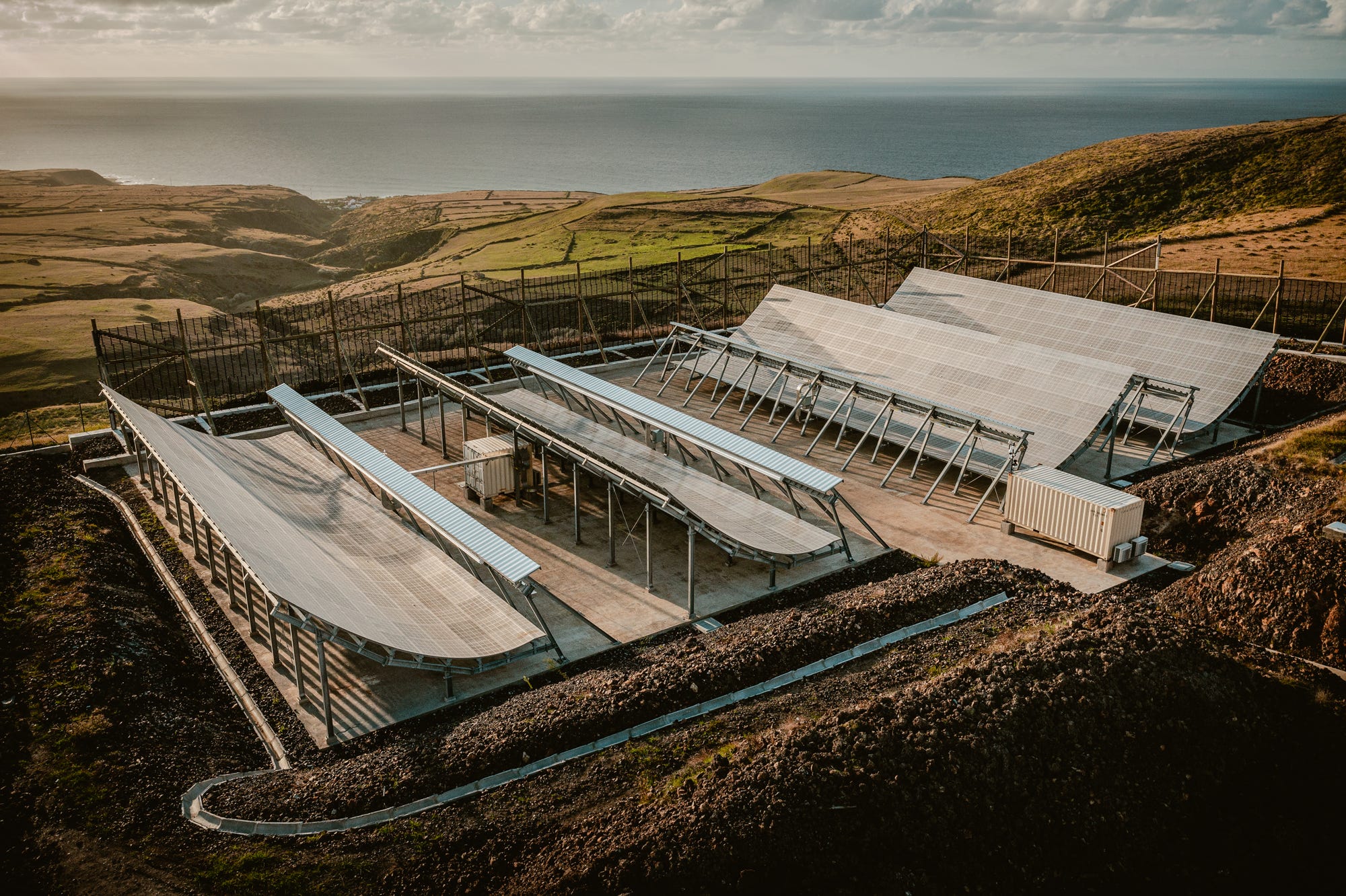
Azores archipelago (Portugal) with a new space radar to track satellites and debris
🛰 The space radar is installed in the teleport area on Santa Maria Island. It allows for collecting data on space debris and satellites located in orbit closer to the Earth (up to 800 to 1,000 kilometers in altitude).

🛰 The radar will cover an area that has never been covered before to track activity in low orbit.
🛰 The radar will track space air traffic, allowing it to support the company's customers, such as Defense organizations, government departments, satellite operators, or space agencies.
📰 Read more (In Portuguese): Santa Maria com radar espacial destinado a rastrear satélites e detritos
📰 Read more (In Portuguese): Ilha de Santa Maria com radar espacial destinado a rastrear satélites e detritos
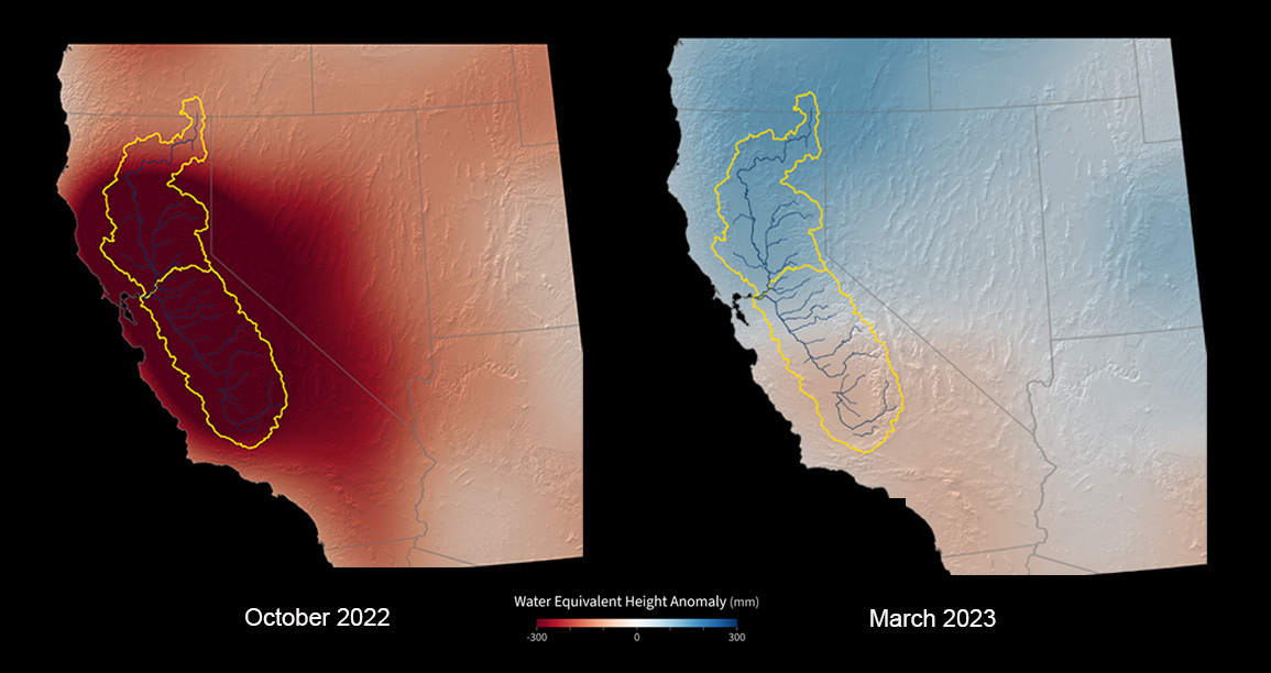
Unprecedented Water Recovery: US-German Satellites Reveal California's Remarkable Post-Winter Progress
After years of intense drought and diminishing groundwater, California just saw its greatest year-over-year water gains in two decades, according to data from the GRACE-FO (Gravity Recovery and Climate Experiment Follow-On) satellite mission, a partnership between NASA and the German Research Centre for Geosciences (GFZ).
This past winter’s bonanza of atmospheric rivers alleviated some of the water deficit that the state incurred during periods of drought over the last 10 years, which included the three driest years on record in California.
📰 Read more: US-German Satellites Show California Water Gains After Record Winter
Early Indications of El Niño Detected by Global Sea Level Satellite
The most recent sea level data from the U.S.-European satellite Sentinel-6 Michael Freilich indicates early signs of a developing El Niño across the equatorial Pacific Ocean.
The data shows Kelvin waves – which are roughly 2 to 4 inches (5 to 10 centimeters) high at the ocean surface and hundreds of miles wide – moving from west to east along the equator toward the west coast of South America.

🛰️ Satellites like Sentinel-6 Michael Freilich can detect Kelvin waves with a radar altimeter, which uses microwave signals to measure the height of the ocean’s surface. When an altimeter passes over areas that are warmer than others, the data will show higher sea levels.
📰 Read more: International Sea Level Satellite Spots Early Signs of El Niño
How Do We Know Mauna Loa Carbon Dioxide Measurements Don't Include Volcanic Gases?
Mauna Loa Observatory, under the operation of the National Oceanic and Atmospheric Administration, holds the extensive and ongoing record of directly measuring carbon dioxide (CO2) levels in Earth's atmosphere. Initiated in 1957, these measurements offer a comprehensive depiction of the dynamic fluctuations of CO2 over seasons, years, and decades.
 monitors greenhouse gases at Mauna Loa Observatory, which is 4 miles (6 kilometers) away from the summit crater. Despite the proximity, volcanic gases aren’t common at the observatory, and when they do happen, these temporary spikes are not included in the long-term data. The decades-long trend of increasing CO2 at Mauna Loa matches that from sampling sites all around the world. Credit: USGS/J. Schmith")
📰 Learn more: How Do We Know Mauna Loa Carbon Dioxide Measurements Don't Include Volcanic Gases?
UPCOMING EVENTS
International Summer School on Earth Observation for Educators
Maximize your potential! Explore the most complete list of training, events, conferences, and workshops at Geoportal.tech. (👥 Jéssica Uchôa)


Thanks for reading! See you next week!
Don't forget to like it and comment.
I appreciate it and I love to hear from you.
With love,
— Rafaela Tiengo