#16 Weekly Remote Sensing and Geoscience news! 🛰️🌍
📢 The Remote Sensing and Geoscience news in 5 minutes.
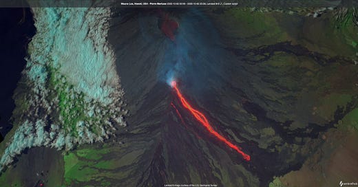
Hawaii's Mauna Loa volcano erupts for the first time in nearly 40 years
🌋 According to the United States Geological Survey, Mauna Loa volcano began erupting in Moku‘āweoweo Caldera on November 27, 2022, at approximately 11:30 p.m. By 6:30 a.m. on November 28, the eruption had migrated to the upper Northeast Rift Zone. No property is at risk currently. There is a visible gas plume from the erupting fissure fountains and lava flows.
🌋 For more information, check out the Mauna Loa Eruption Webpage on USGS website:
Mauna Loa Eruption Webpage | USGS — www.usgs.gov


Scene From Above Podcast: episode 2 is out!
🎙️ This episode features Dr. Karen Joyce, an Associate Professor at James Cook University in Cairns, Australia. Dr. Joyce is an innovator of all things Earth Observations from science to creating community. In her research, she explores novel usages of drone platforms building upon her experience in the military. Outside of her research, she is an entrepreneur who has led the development of the GEONadir drone data sharing and processing platform as well as created an educational network and resources for introducing young girls to UAVs called Shemaps. She is also a founder of the Dames of Drones network!
🎙️ Listen to hosts Dr. Morgan Crowley and Dr. Gopika Suresh talk to her about this and more in this episode.
🎙️ I am the news correspondent of the podcast and I talked about the most recent news about remote sensing and geoscience. Happy listening! :)


Tip: how to create map legends with only one line of code?
The amazing Dr. Qiusheng Wu will help you at the link below!
Qiusheng Wu on LinkedIn: — www.linkedin.com Leafmap Tutorial 59 - Creating map legends with only one line of code Video: https://lnkd.in/eAj3HN8f Notebook: https://lnkd.in/eExc-5d8 JupyterLite...
I would like to take this opportunity to thank Dr. Qiusheng Wu for all his amazing work and the valuable contributions he makes to our scientific community! 🌍💚
Conference: GeoPython 2023
Main Topics
🛰️ GIS/Mapping
🛰️ Geography/Geophysics/Geodesy/Geomatics
🛰️ Earth Sciences/Environmental Sciences
🛰️ Spatial Data/Geodata
🛰️ Big Data
🛰️ Computer Vision
🛰️ Remote Sensing
🛰️ Machine Learning/Deep Learning
...and more!
Important Dates
➡️ Submission Deadline Talks: December 16, 2022
➡️ Submission Deadline Workshops: December 16, 2022
➡️ First Draft Schedule: January 16, 2023
➡️ Conference: March 06-08, 2023
➡️ Hackathon GeoHack: March 09-10, 2023 (Separate Registration)
Check the GeoPython conference website:
GeoPython 2023 — 2023.geopython.net The Python conference for Geo, March 06-08, 2023, Basel, Switzerland
If you are interested in this conference and/or are planning your next year's events, check out my last newsletter issue. I already summarize and created a list of conferences in 2023 to help you and I am often updating it! Check it out on the link below!
#15 Weekly Remote Sensing and Geoscience news! 🛰️🌍 — www.getrevue.co
This week we have bonus information: 2023 CONFERENCE LIST.
Course: Connecting Citizen Science with Remote Sensing
By the end of this training, attendees will be able to:
🛰️ Summarize applications of Earth Observations for citizen science
🛰️ Outline key aspects of citizen science projects including community engagement, quality assurance of data collection, cataloging and summarizing data, and effective communication of project results
🛰️ Discover case study examples of the use of Earth Observations for NASA Applied Sciences projects
ARSET - Connecting Citizen Science with Remote Sensing | NASA Applied Sciences — appliedsciences.nasa.gov
This training will provide attendees an overview of citizen science efforts that use Earth Observations, and how to engage with community members in a supportive and meaningful manner to achieve project goals.


